Sept 19th Ladakh adventure begins…
My travel companion K and I left Keylong at 5:00 a.m. to head to Leh. The wonderful and inspired Lahauli adventure had come to an end, and it was now time for Ladakh!
It was a long drive of about 11-12 hours on the Manali-Leh Highway, with stops for photos, breakfast and lunch. Unbelievable rugged terrain that seems to endlessly unfurl its textural vistas as you drive along hour after hour. Empty, cold, semi-arid desert across vast mountain ranges.
Like the road trip from Spiti to Lahaul, the land is at once austere and captivating. Fortunately, unlike the jagged, unpaved highway from Spiti to Lahaul, this one was rather well-paved and maintained. Besides tourists, it’s well-used by the military guarding the Sino-Indian border, and there are checkpoints along the way where all vehicles must stop and register passing through.
En route, one passes places with quaint names like Zingzingbar and Lachulung-la, ascending ever higher. From our starting point at Keylong, it’s 3349 meters altitude going up to the high point of Tanglang-la of 5328 meters. I felt short of breath at times, but thank goodness I’m long over altitude adjustments (the first week in Spiti was vice-grip-like, headache-filled nights in addition to shortness of breath), though it is no joke to continue to take precautions and be aware of the dangers of high altitude sickness. People can die from it, and pretty quickly, too.

There are no villages or towns the whole stretch of road from Keylong to Leh, only roadside stops for food or overnight stays. These are makeshift temporary seasonal tents that offer cots for travelers to sleep in and a basic menu of dishes such as paranthas, rice and dahl, chow mein. Breakfast was at one of these places.

Shortly after taking off on the road again after breakfast, we saw this. Can you spot the little guy in the below photo?

Didn’t see him? Okay, then look here…

 Marmots were poking their heads out of rock crevices, or walking out in the open like this one, presumably searching for breakfast. Cute pudgy little things, they reminded me of our local American groundhogs.
Driver G was really nice, good conversationalist, great driver. He is a trekking guide and luxury tent campsite owner in Manali who conducts Himalayan adventure trips. He is also an old friend of K’s. K said G saved his life once on a mountaineering trip.
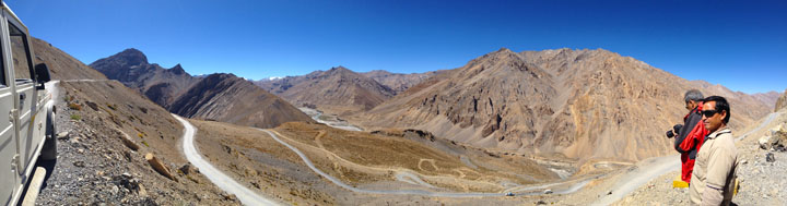
With his four wheel drive flatbed truck, he would deftly take uphill shortcuts connecting switchback roads, such as here at the Gata Loops, the part of the highway famed for its 21 hairpin turns.


Kangla Jal trekking pass point and India Gate reminds me of out West in Zion or Bryce Canyons in the U.S.


Lunch was at another tent site, where people really make do with little water and toilets are open air. One gets good at finding large rocks to befriend!

Not long after leaving the lunch site, we came upon the plateau portion of the trip called Morey Plains. Instead of traveling through passageways and valleys, this section was a wide open flat expanse of land.


The Himalayan mountains along the way are diverse in colors and shapes. Some are more black like these below, and others more pink and warm flesh tones gradating into earth reds as you see more of as you get closer to Leh.


When we reached Tangla-la, the high point with an altitude of over 17,500 feet, it was marked by a large shrine and elaborate prayer flags. Other travelers stopped for a gander and to marvel that they, too, had made it to this point on the road to Leh. Inside the shrine there were Hindu and Buddhist deities.


How did people in ancient times manage traveling through this rough barren terrain? Actually many of them didn’t and perished along the way. I’m thinking of Rinchen Zangpo’s party of 21, whom King Yeshe O’d sent from Guge, Western Tibet, to India in the late 10th century, only 2 of whom made it back alive.

As you get closer to the city of Leh on the highway, you begin to see stupas and chortens in the landscape. This little monastery is among the first signs of permanent dwellings as you come out of the hinterlands and approach civilization, still about two hours’ drive before reaching the outer monasteries of Leh, such as Stakna.


